
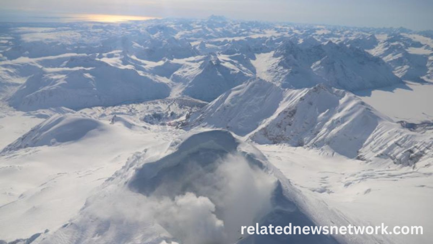
Alaska’s Mount Spurr, a prominent stratovolcano located approximately 80 miles west of Anchorage, has recently experienced a notable surge in seismic activity. This increase in ground tremors has captured the attention of geologists and volcanologists, suggesting that subterranean forces may be preparing for an eruption. Earthquake swarms beneath the volcano, especially those concentrated near its summit, indicate that magma is likely moving upward through fractures in the Earth’s crust. These seismic signals are a critical early warning sign in the volcanic activity spectrum.
Ground Deformation Signals Magmatic Movement
In addition to seismic disturbances, satellite and ground-based instruments have detected significant ground deformation in the region. GPS stations situated around Mount Spurr have recorded measurable uplift and horizontal shifts. Such deformations typically occur when magma accumulates in underground chambers, exerting pressure on the surrounding rock layers. This phenomenon strongly implies that molten rock is intruding into the crust, potentially forming new magma pathways that can lead to surface eruption.
Gas Emissions Point Toward Pressurization
Elevated levels of volcanic gases such as sulfur dioxide (SO₂), carbon dioxide (CO₂), and hydrogen sulfide (H₂S) have been measured at various monitoring sites around the volcano. These gases are often released as magma ascends, releasing pressure from deep reservoirs. The chemical composition and volume of these emissions suggest that volatile-rich magma is nearing the surface, increasing the likelihood of an explosive eruption scenario. The persistent outgassing trend further supports the hypothesis of imminent volcanic unrest.
Read More : 20 of the Most Adorable Animals To Help Make Anyone’s Day
Historical Eruptions Offer Important Clues
Mount Spurr has a history of explosive eruptions, the most recent significant one occurring in 1992. That eruption resulted in widespread ashfall over south-central Alaska, including Anchorage, disrupting air travel and affecting daily life. By analyzing past events, scientists can model potential eruption outcomes and estimate the scale of future hazards. Historical data from the 1953 and 1992 eruptions provide a framework for understanding the current activity, especially in terms of eruption style and ash dispersion patterns.
Potential Hazards to Surrounding Regions
Should Mount Spurr erupt, a number of hazards could pose serious threats to the surrounding areas. Ash plumes may reach altitudes that interfere with commercial air traffic routes, posing a significant risk to aviation safety. Pyroclastic flows, lava flows, and lahars could impact ecosystems, infrastructure, and communities located along rivers and drainage systems fed by glacial meltwater from the volcano. Additionally, air quality in nearby cities could deteriorate rapidly due to ash and gas emissions.
Scientific Monitoring Efforts Intensify
The Alaska Volcano Observatory (AVO) has elevated Mount Spurr’s alert level and aviation color code in response to recent developments. Teams of volcanologists and geophysicists are working around the clock to analyze data from seismic stations, GPS units, satellite images, and gas sensors. Real-time monitoring is being supplemented with drone surveys and thermal imaging, providing a comprehensive view of the volcano’s condition. These efforts are vital for issuing timely warnings and minimizing potential impacts on human life and property.
Read More :
Preparedness Measures for Communities and Travelers
Local authorities have begun coordinating with emergency response agencies to develop contingency plans in case of an eruption. Public information campaigns are underway to educate residents and travelers about evacuation routes, emergency supplies, and protective measures against ash inhalation. Anchorage’s airport and nearby military installations are also on high alert, preparing for the possibility of air traffic disruptions and logistical challenges that may arise from volcanic fallout.
Global Scientific Community Watches Closely
The unfolding situation at Mount Spurr has attracted the attention of volcanologists around the world. Research institutions are sharing data and models in real-time to enhance understanding and prediction capabilities. This collaborative effort reflects a broader scientific goal of improving eruption forecasting through interdisciplinary study, using Mount Spurr as a live case study of a potentially eruptive system.
Frequently Asked Questions
Where is Mount Spurr located?
Mount Spurr is located in Alaska, approximately 80 miles west of Anchorage, within the Aleutian volcanic arc.
What type of volcano is Mount Spurr?
It is a stratovolcano, known for its steep profile and explosive eruption potential.
What signs suggest Mount Spurr may erupt soon?
Increased seismic activity, ground deformation, and elevated volcanic gas emissions suggest that magma is rising beneath the volcano.
When was the last eruption of Mount Spurr?
Mount Spurr last erupted in 1992, sending ash clouds that affected air traffic and cities like Anchorage.
How is Mount Spurr monitored?
The Alaska Volcano Observatory monitors the volcano using seismic sensors, GPS stations, gas detectors, satellite imagery, and drones.
What are the potential hazards of a Mount Spurr eruption?
Hazards include ashfall, pyroclastic flows, air travel disruption, lahars, and degraded air quality in nearby regions.
Can an eruption impact international flights?
Yes, ash clouds from an eruption could interfere with major flight paths over Alaska, impacting international air travel.
What should nearby communities do to prepare?
Stay informed through official alerts, prepare emergency kits, and follow local evacuation plans if necessary.
Conclusion
Mount Spurr is exhibiting clear warning signs of volcanic unrest, prompting close observation by scientists and emergency planners alike. While the exact timing of an eruption is uncertain, the combination of seismic activity, gas emissions, and ground deformation points toward a rising threat. Vigilance, preparedness, and scientific monitoring will be essential in minimizing potential risks as the region anticipates what could be a significant volcanic event.